en Web en Blog

Somos puntanos, orgullosos de esta hermosa y querida Provincia.
En los paseos de fin de semana registramos imágenes y te relatamos los viajes por el interior de San Luis.
Vos sos nuestro acompañante...
Aún nos falta mucho por recorrer. ¿Disfrutemos Juntos?
Prohibido su reproducción total o parcial (derechos de autor Ley 11723)


PARA AGILIZAR EL SISTEMA MOSTRAMOS LAS DIEZ ÚLTIMAS PUBLICACIONES, EL RESTO UD PODRÁ ENCONTRARLO EN EL MENÚ QUE SE ENCUENTRA A LA DERECHA... PARA AGRANDAR LAS IMAGENES, HACER CLIC SOBRE ELLAS
Mostrando las entradas con la etiqueta Departamento Ayacucho. Mostrar todas las entradas

domingo

Camino que une las localidades de La Carolina y San Francisco I


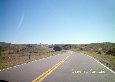
La Provincia de San Luis cuenta desde este año – 2010 – con uno de los caminos serranos más bellos del País, y sin dudas recorre uno de los paisajes más atractivos de todo nuestro territorio provincial. Es el que une las localidades de La Carolina en el Dpto. Pringles con San Francisco del Monte de Oro – Dpto. Ayacucho. Son 35 kilómetros de ruta pavimentada, en parte con asfalto y en parte con hormigón, ya que sus pronunciadas cuestas y cerradas curvas así lo aconsejan.

Apenas se sale del pueblo de Carolina comienzan a mostrarse afloraciones rocosas de increíbles formas y colores y de escasa vegetación, ya que se transita por la zona más alta del territorio provincial – a casi 2.000 metros de altura sobre el nivel del mar.Luego de aproximadamente 10 kilómetros nos encontramos con el Cerro El Amago en cuya cumbre se ha instalado una repetidora del canal de Televisión Provincial, por ser un lugar estratégico para dotar de la señal televisiva tanto a Carolina como al Valle de San Francisco y aledaños.


El trazado de este camino y el trabajo que ha costado realizarlo, rodeado de una naturaleza por demás pródiga, hace que nos emocionemos por contar con una obra de tamaña magnitud y un paisaje en el que la mano de Dios ha sido generosa




+

The province of San Luis has since this year - 2010 - with one of the most beautiful mountain roads in the country, and certainly runs one of the most beautiful of all our province. It is the road linking the towns of La Carolina in the Department Pringles San Francisco del Monte de Oro - Ayacucho Department. There are 35 miles of paved road, partly with asphalt concrete and partly because its steep hills and hairpin turns make it appropriate. Hardly Carolina leaves the village of rocky outcrops begin to show incredible shapes and colors and sparse vegetation, as it passes through the highest part of the county - nearly 2,000 feet above the sea level. After about 10 km we find the Mount Amago on whose summit has installed a repeater channel Provincial Television, being a strategic location to provide the television signal to both Carolina and the San Francisco Valley and beyond. Alongside the descent begins an incredible journey of snails that will take us down after nearly 1,800 meters near San Francisco. It's a somewhat narrow path but absolutely sure, because he was delineated on the old road with all the works of art and elements of security for those traveling through the area. Of course, the drivers of the vehicles have to take every precaution, and ascend or descend - as appropriate - on a mobile in perfect condition. In some parts the road is ledge, and can be seen down the river course. There are many suitable places to stop and take pictures, shoot or simply contemplate the magnificence of the place. Here the vegetation changes abruptly as due to the orientation of the mountain slopes are much more moisture and can appreciate a deep green and colorful flowering plants - at least in summer -. The route of this road and the work that has costs incurred, surrounded by a bountiful nature for others makes us excited to have a work of such magnitude and a landscape in which the hand of God has been bountiful to others. After traveling another 20 miles, which we forded the river several times, we approach the future construction site of the dam over the Rio Claro, a dam that will serve as a reservoir of water for irrigation and human use and as a new attraction resort to this heavenly place which itself already has many corners to be chosen for your next vacation.


(para agrandar la información del tamaño de la pantalla haga click sobre MENU- VIEW FULLSCREEN. Para volver al tamaño original, apretar la tecla ESC de su teclado)

Camino que une las localidades de La Carolina y San Francisco


miércoles

Quines - Dpto. Ayacucho San Luis


Quines , ubicada en el Dpto Ayacucho a 145 Km de la Ciudad capital sobre la Ruta Nacional 146, es una de las localidades más importantes del Norte provincial, por su población y por la importancia económica que data desde la época en que sus explotaciones de leña y carbón disminuyeron considerablemente el bosque nativo de la región.
Su nombre es de origen indígena y podría significar “Tierra caliente” Las primeras referencias históricas se remontan al año 1673 cuando esas tierras fueron otorgadas en merced al Capitán Domingo Sánchez Chaparro
Quines, located in the Department of Ayacucho 145 km from the capital city on National Route 146, is one of the most important Northern province, its people and the economic importance dating from the time that their holdings of firewood and coal declined considerably native forest in the region. His name is of indigenous origin and could mean "hot earth" The first historical references go back to the year 1673 when these lands were granted at the mercy Captain Domingo Sánchez Chaparro


Plaza Crisóstomo Lafinur

En la actualidad un templo más moderno ocupa una de las calles principales del pueblo frente a la plaza principal.
Existe enorme veneración por la Virgen del Rosario, esta se ve reflejada año tras año, cuando miles de personas se encolumnan en procesión.
Las artesanías tienen un amplio desarrollo en la región.
At present a more modern temple occupies one of the main streets of the village off the main square. There is enormous reverence for the Virgin of the Rosary, this is reflected every year, when thousands of people were encolumnan in procession. Handicrafts have a comprehensive development in the region.

Trabajos en madera de algarrobo, tejidos en telar, curtidos y tallados en cuero, torneado de madera, son las principales actividades de muchos habitantes de Quines.
Jobs in wood carob, loom fabrics, leather and leather carving, wood turning, are the main activities of many inhabitants of Quines


Desde 1937 y por más de 50 años Quines contó con un ramal de ferrocarril proveniente de La Rioja, a donde salían los frutos del país, que se extraían de la zona.
Quines cuenta micro-clima subtropical, lo hace un área privilegiada para el turismo en general, además por su proximidad a las serranías. Con temperaturas óptimas en verano entre los meses de diciembre y enero que rondan máximas de 40° y los inviernos benignos en razón por su altitud sobre el nivel del mar.
Since 1937, and for more than 50 years Quines was a branch railway from La Rioja, where they left the fruits of the country, which were drawn from the area. Quines account micro-subtropical climate, what makes a privileged area for tourism in general, in addition to its proximity to the mountains. With summer temperatures best between the months of December and January to peak at around 40 ° and winters in benign reason for its altitude above sea level.


Parroquia San José

Frente a la plaza nueva, se encuentra la Igesia de San José, cuyo origen hay que encontrarlo en la petición de urbanizacón y ofrecimiento de tierras realizado al Gobernador Agustín Ortíz Estrada en 1871 por un grupo de vecinos, entre los cuales podemos citar a Justo Montiveros, Javier Alaniz y a Eduardo Leyes, quienes ofrecían tierras para la Iglesia, la plaza, calles y solares para los pobladores que deseen edificar.
Si bien se realizó el trazado de la nueva villa en el año 1873, se pidió al gobierno un subsidio en vista que la construcción del templo tardaba en iniciarse. A pesar de todo pasaron muchos años, hasta que en 1897 se comenzó la construcción del mismo, finalizandolo en 1904.La torre fue mandada a construir por el Pbro. Manuel Beltrán en 1908.
El Nuevo Templo se puso bajo la advocación de San José y la Iglesia perteneció a la Parroquia de Luján desde 1917 hasta 1976 año en que fue elevada al rango de Parroquia por Monseñor Rodolfo Laisse.

Faced with the new plaza is the Igesia San Jose, whose origin must be found in the request for urbanisation and land offer made to the Governor Agustin Ortiz Estrada in 1871 by a group of neighbors, among whom we quote Just Montiveros Javier Alaniz and Edward Law, who offered land for the church, the square, streets and areas for residents who wish to build. While it made the route of the new town in the year 1873, it asked the government for a grant given that the construction of the temple was slow to start. Despite all spent many years, until in 1897 began the construction of the same, finalizandolo in 1904. The tower was commissioned to be built by Fr. Manuel Beltran in 1908. The new temple was under the advocation of St. Joseph Church and belonged to the parish of Lujan from 1917 until 1976 when it was elevated to the rank of parish by Monsignor Rodolfo Laisse.

martes

Quines - II Parte -Dpto Ayacucho San Luis


En la zona serrana próxima a la localidad se pueden disfrutar hermosos lugares aptos para la natación y el turismo de aventura.


El Muro aproximadamente a 5 km. del centro de Quines, posee asadores, piletas, lugar para camping y un quincho, con todos los servicios.

El Río grande de Quines tiene en este lugar arenas de un extraño color rojizo que le da un colorido muy particular al balneario.


El Zapallar a 7 km. de la localidad, con un arroyo de cristalinas aguas y pileta de natación, ofrece además a los veraneantes el agregado de la pureza de sus aguas termales. Desde este lugar ascendiendo a las sierras se llega a lugares de una belleza incomparable, como "Los Cocos" y miradores con bellísimos panoramas

La construcción de la chimenea, data de más de medio siglo; comenzó aproximadamente, a mediados de 1948 y, se puso en funcionamiento a mediados de 1949 el aserradero "Santa María".
En él llegaron a trabajar 200 personas entre hombres, mujeres y niños.
El aserradero constituyó el medio y el modo de vida de centenares de familias.
In the mountainous area near the town can enjoy beautiful places suitable for swimming and adventure tourism. The Wall approximately 5 km. From the center of Quines, has grills, sinks, and a place for camping quincho, with all services. The Rio large Quines have here sands of a strange reddish gives a very colorful particular spa. The Zapallar 7 km. Of the town, with a stream of crystal clear water and swimming pool, also offers vacationers the addition of the purity of its hot springs. From this place, climbing the mountains to reach places in a beautiful, as "The Coconuts" and viewpoints with beautiful vistas The construction of the fireplace, dating back more than half a century, began around in mid-1948 and was put into operation in mid-1949 the mill "Santa Maria". The 200 people came to work for men, women and children. The sawmill was the environment and the livelihood of hundreds of families.

lunes

Luján San Luis Parte I - (Dpto. Ayacucho)

Oficinas Públicas

Plaza principal de Luján


Iglesia Nuestra Sra. de Luján
LUJAN es una población de unos 2000 habitantes, ubicada en el Dpto Ayacucho a 130 Km de la ciudad de San Luis, sobre la Ruta Nacional Nº 146.
Sus primeras casas se construyeron en las inmediaciones del denominado Rio Seco, por lo que al paraje se lo denominaba así.
Alrededor de 1850 el Coronel Juan Francisco Loyola mandó a edificar una Iglesia en honor de Nuestra Señora de Luján, que recibía a los fieles de toda la zona, por lo que el lugar – y también el río – cambiaron de nombre, reconociénselos como Luján.
La población cobró importancia por la actividad económica de la región. Sus calles se caracterizaron luego por su arboleda de naranjos.

A pocos kilómetros se construyó un dique que embalsa las aguas de los arroyos San Lorenzo y Las Palmitas y aunque de pequeñas dimensiones su panorama es bellísimo, encerrado entre los Cerros Bandera – de 1550 metros – e Independencia de 1420 metros. Un imponente muro , suelta parte de su caudal para riego y bebida, dejando ver otra magnífica postal.
En sus cercanías se encuentra la Quebrada de Las Higueritas , un área natural protegida, donde existen aves canoras en vías de extinción y ejemplares de la fauna autóctona., exuberante y boscosa debido al clima templado y húmedo.Antes de su ingreso, el Municipio ha construido un calvario, cuyas estaciones se utilizan para semana santa y otras festividades litúrgicas de la Iglesia Católica

LUJAN is a population of about 2000 inhabitants, located in the Department of Ayacucho 130 km from the city of San Luis on National Route No. 146. Its first houses were built in the vicinity of the so-called Rio Seco, so that the spot was well known. Around 1850 Colonel Juan Francisco Loyola ordered to build a church in honor of Our Lady of Lujan, who received the faithful of the whole area, so the place - and the river - changed names reconociénselos as Lujan. The settlement became important for economic activity in the region. Its streets were characterized by then his orange grove. A few kilometres we built a dike that embalsa waters of the creeks San Lorenzo and Las Palmitas and although his small picture is beautiful, enclosed in the Hill Tracts flag - 1550 meters - and Independence of 1420 meters. An impressive wall, release part of its flow for irrigation and drinking, leaving another magnificent view postcard. In its vicinity is the Quebrada de Las Higueritas, a protected area, where there are birds endangered songbirds and copies of the native fauna. Exuberant and forest because of the temperate climate and húmedo.Antes of their income, the municipality has built an ordeal, whose stations are used for Easter and other liturgical celebrations of the Catholic Church

Luján San Luis Parte II - (Dpto. Ayacucho) - Via Crucis e Imágenes del Dique Lujan


Cerro Bandera, está situado a 6 kilómetros del ingreso a Luján, en la costa del dique.Desde este imponente cerro de 1550 metros sobre el nivel del mar, se aprecia un incomparable paisaje, en primer plano, de todo el embalse y los grandes cerros que lo encajonan.Situado a 200 metros de altura del río Luján, se deja ver al fondo la gran llanura del Oeste de la Provincia de San Luis.

Cerro Bandera, is located 6 kilometers from the entrance to Lujan, on the shore of the dam. From this imposing hill of 1550 meters above sea level, there is an incomparable landscape, in the foreground, around the reservoir and large hills that encasing. Located at 200 meters high river Lujan gets to see the substance of the great plains west of the Province of San Luis


Este embalse está construído en 1958 sobre el río Luján, formado por la unión de los ríos San Lorenzo y Las Palmitas, cuenta con una superficie de 27 hectáreas, cuyo caudal medio es de 0.380 m3/s.
Su costa es escarpada, sólo hay un sector donde se puede acceder a través de un pequeño terreno de 6 x 30m, que se le ha ganado al dique.
Posee poca utilización recreativa, ya que por sus características, darse baños es peligroso. El sector utilizable es la cola del dique, que conforma una pequeña playa, a la que se accede atravesando el dique en balsa.
La vegetación representada en los alrededores del embalse con molles, talas, algarrobos, chañares, entre otros.
Posee una perspectiva visual totalmente cerrada, ya que se ubica en un recodo del río Luján y se encuentra rodeado por grandes cerros como el Independencia y el Bandera, que ofician además de refugio de cóndores.
This reservoir was built in 1958 on the river Lujan, formed by the union of the St. Lawrence rivers and Las Palmitas, has an area of 27 hectares, whose average flow is 0,380 m3 / s. Its coastline is rugged, there is only one sector where it can be accessed through a small field of 6 x 30m, which he has won the dike. It has little recreational use, since by their nature, give baths is dangerous. The sector is usable tail dam, which forms a small beach, which is accessed through the dam raft. The vegetation represented in the vicinity of the reservoir with molles, logging, carob, chañares, among others. It has a visual perspective completely closed since it is located on a bend of the Lujan, it is surrounded by large hills as the Independence and the flag, who function well as a haven for condors